Route 66 Road Trip: 13 Days from Chicago to Los Angeles
The Mother Road deserves honesty up front: Route 66 was decommissioned in 1985, and most of its pavement now lies under Interstate 55, 44, 40, 15 and 10, so this 13-day drive runs the surviving two-lane fragments between the interstates rather than pretending a continuous old road exists. What survives is the point: neon signs, diners, the Chain of Rocks bridge over the Mississippi, the Cadillac Ranch, Seligman's barbershops, the Grand Canyon's South Rim and the End of the Trail sign on the Santa Monica Pier. This guide carries the numbers that matter: roughly 2,600 miles, Petrified Forest's US$25 park fee, the Grand Canyon's US$35 vehicle fee plus the US$100 per-person surcharge for non-US residents unless you hold the America the Beautiful pass.
Route: Chicago St. Louis Oklahoma City Albuquerque Grand Canyon Los Angeles
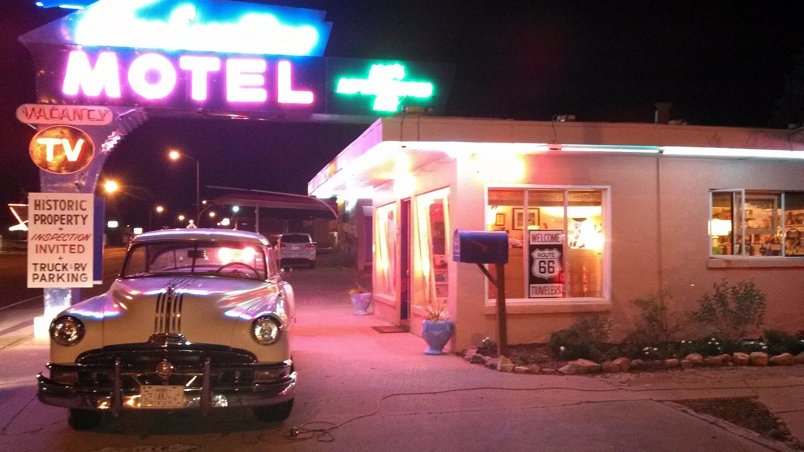
The truth that separates a great Route 66 trip from a disappointing one: the road as a legal highway was decommissioned in 1985, and interstates I-55, I-44, I-40, I-15 and I-10 now carry most of the traffic over the old right of way. The romance did not die with it. This 2,600-mile loop delivers the real artifacts: 1920s bridges, neon motel signs, Mexico-shaped diners, the strongest small-town Americana left on the continent, and the Grand Canyon at the end of it. Drive it as a scavenger hunt along interstate corridors, hopping off for the historic alignments, and give the canyon two full days. Thirteen days is the right pace; ten would break you.
Day 1: Arrive in Chicago, Find the “Begin” Sign
Pick up the rental car in the evening or plan to collect it on Day 2 morning, because Chicago is a walking city: the Bean in Millennium Park, the riverwalk, and deep-dish if your cardiologist has signed off. The official start of Route 66 is a sign on East Adams Street at Michigan Avenue, one block off Grant Park; photograph it at dusk when the traffic thins. Keep the car out of the Loop, since downtown parking runs US$50 to 70 a night at hotels, a fee that buys nothing but the privilege of storage.
Practical tip: Rent the car for the morning you leave rather than the day you land: three unnecessary downtown parking days cost more than the airport transfer ever will, and the historic alignment west of the city starts within minutes of leaving the Loop.
Day 2: Chicago to St. Louis via the Illinois Alignments
Leaving on old Route 66 means I-55 with regular exits onto the surviving frontage alignments. The Midwest stops are whimsical giants: the Gemini Giant astronaut muffler-man in Wilmington, the two-story dog in Gardener, and Atlanta’s muffler man hugging a hot dog. The Cozy Dog Drive In on the Springfield alignment, which claims invention of the corn dog on a stick, earns your first genuine diner lunch of the trip. As you approach St. Louis, detour to the Chain of Rocks Bridge, the 1929 crossing with a mid-span bend that carried Route 66 over the Mississippi; it is now a free pedestrian bridge, so walk out to the bend for the river view. Overnight in St. Louis, roughly 300 miles behind you.
Practical tip: I-55 is monotonous by design, so the game is exit archaeology: scan the historic alignment in your navigation app before each segment, because the brown Route 66 signs only mark the fragments, and the frontage roads carry them.
Day 3: St. Louis: the Arch and Frozen Custard
Give the whole morning to the Gateway Arch, the 630-foot stainless steel curve that anchors the Jefferson National Expansion Memorial; tram capsules to the top are timed tickets that sell out, so book ahead at gatewayarch.com, and the museum underneath is free and genuinely excellent. Afternoon options: the City Museum, a repurposed shoe factory that is part playground, part art installation and beloved by adults, or the Missouri History Museum. Route 66 tradition requires frozen custard at Ted Drewes on Chippewa Street, an old alignment institution serving “concrete” malts so thick they are served upside down.
Practical tip: Book the Arch tram for the first slots of the morning: the pods hold five people each and board on exact times, and by early afternoon the wait at security runs long, since it is a federal facility with airport-grade screening.
Day 4: St. Louis to Springfield, Missouri
Today the road goes properly Ozark. Old 66 climbs out of St. Louis through hills, ending the Midwest’s flat-line monotony. Stop at Meramec Caverns in Stanton, a commercialized show cave that has been selling tours since the 1930s, gaudy and fun and air-conditioned at 60 degrees Fahrenheit year round. Continue through Lebanon (the Munger Moss Motel sign is one of the road’s great neon survivors) into Springfield, which local historians credit as the place where the name “Route 66” was proposed at a 1926 meeting. Roughly 215 miles today, all of it two-lane nostalgia.
Practical tip: Caves run a constant 60 degrees: carry a light layer in summer or the tour’s first ten minutes are miserable, and buy cave tickets at the door, since tours run continuously and rarely sell out except holiday weekends.
Day 5: Springfield to Oklahoma City via Tulsa and the Blue Whale
Around 285 miles with the best stop density of the trip. Cross into Kansas for barely 13 miles of Route 66 (Galena, with the Cars-movie inspiration towing truck), then Oklahoma: the Blue Whale of Catoosa, a concrete whale in a pond built as a wedding anniversary gift in 1972 and now the road’s most beloved photo stop. Tulsa rewards an hour with the Cyrus Avery Route 66 memorial and Buck Atom’s space cowboy. The drive into Oklahoma City ends at the western edge of the oil capital, where Route 66 icons like the Milk Bottle Grocery sit in active neighborhoods rather than behind velvet ropes.
Practical tip: The Blue Whale fills with tour vans mid-morning: hit it before 10 a.m. and you get the pond and picnic tables to yourself, and the 13 Kansas miles are so short you will miss them without a navigation pin, so set one.
Day 6: Oklahoma City: Stockyards and Route 66 Heritage
A driving rest day. Oklahoma City rewards it: the National Cowboy and Western Heritage Museum is a genuinely world-class art collection with a frontier town reconstruction inside, and the Stockyards district still runs real cattle auctions alongside the gift shops. For Route 66 texture, drive the alignment along 39th Street past the Tower Theater district, then spend the afternoon at the Oklahoma Route 66 Museum an hour west in Clinton if you want the canonical exhibit on the road’s Dust Bowl migration history, or stay in town and rest by the pool, because tomorrow is the trip’s long haul.
Practical tip: This is the day to do laundry, top up prescriptions and download offline maps for Arizona: the next four days cross Indian Country and the Mojave with long service gaps, and the 66 nostalgia fades fast if you break down unprepared.
Day 7: Oklahoma City to Albuquerque: the Long Haul
Roughly 450 miles, the day the road earns its “don’t rush” reputation. Break it at Amarillo: the Cadillac Ranch, ten Caddys buried nose-down in a field, free to visit and encouraged to paint (bring a can), and lunch at the Big Texan if the 72-ounce steak challenge amuses you. West of Amarillo, old 66 runs alongside the interstate through Adrian, mid-point of the road by its own sign, and into New Mexico, where the terrain turns red and the time zone shifts. Albuquerque arrives with the Sandia mountains glowing at sunset.
Practical tip: Fuel discipline starts here: between towns on the high plains, stations run 50 miles apart and some close early, so refill at half a tank, and remember New Mexico’s mountain stretch means the last hour is down a long grade at night with elk on the road.
Day 8: Albuquerque: Old Town and the Tramway
Albuquerque deserves its full day. Morning: Old Town’s adobe plaza, settled in 1706, and the Indian Pueblo Cultural Center, which puts the 19 Pueblo communities’ history and living culture in proper context, a needed corrective to the souvenir version. Ride the Sandia Peak Tramway after lunch: 2.7 miles up to 10,378 feet on the longest span of its kind in the country, with the whole Rio Grande valley laid out below; buy tickets online at sandiapeak.com, and adult fares have recently run around US$30. Dinner is green chile on everything, which in Albuquerque is not a suggestion but grammar.
Practical tip: The tram closes for weather and runs Wednesday through Monday at present (check the site), so if your visit falls on a Tuesday, flip this day with the Grand Canyon drive, and book the tram slot for late afternoon when the valley light turns gold.
Day 9: Albuquerque to the Grand Canyon via Petrified Forest
The day that justifies renting an SUV with a panoramic roof. West on I-40, and inside Petrified Forest National Park the old road literally crosses the park, marked by a 1932 Studebaker; the park holds US$25 per vehicle entry (seven days, card only), and the Painted Desert’s striped mesas are visible from the road itself. Continue to Williams, the last Route 66 town bypassed by the interstate (October 1984, per its own monument), and overnight there or in Tusayan at the canyon gate. Total mileage lands near 430, the trip’s second-biggest day.
Practical tip: Enter Petrified Forest from the north (Painted Desert) exit at the south for the classic one-way drive through the petrified log fields; the park closes at dusk and there is no lodging inside, so time your arrival for mid-afternoon at the latest.
Day 10: Grand Canyon South Rim
The trip’s payoff needs no neon. The South Rim takes no entry reservation (US$35 per vehicle, seven days, card only), but non-US residents aged 16 and over currently pay an additional US$100 per person unless the vehicle holds an annual or America the Beautiful pass, so run the math: for two international travelers, the US$80 pass bought in advance at recreation.gov saves US$220 on the spot. Walk the Rim Trail between Mather Point and the village, take the free Hermits Rest shuttle along Hermit Road, and end at Desert View Watchtower for sunset, where the Colorado River’s gorge unrolls to the east.
Practical tip: Sunrise beats sunset at Mather Point by an hour and a crowd, the canyon’s inner heat is real even in spring, and anyone going below the rim on foot needs real water and real insurance, because the nearest major hospital is in Flagstaff and American emergency care without coverage is a five-figure surprise (our health and safety guide covers what to carry).
Day 11: Grand Canyon to Kingman via Seligman
The classic Route 66 day, all survivors. Drop back through Williams to Seligman, where barber Angel Delgadillo’s 1987 campaign to revive the old road effectively started the entire Route 66 preservation movement; the Delgadillo family’s Snow Cap Drive-In still serves wisecracking cheeseburgers. Then the longest uninterrupted stretch of original 66 left in Arizona, over the Black Mountains past Hackberry General Store’s abandoned gas pumps, into Kingman, home of the Arizona Route 66 Museum. Around 180 miles, so take it slow: this is the day you stop at every sign.
Practical tip: The original alignment through this stretch drops grades and hairpins between Seligman and Kingman; it is fully paved and any rental car can do it, but check the brakes on the descent and do it in daylight, because the old road at night with deer on it is a different sport.
Day 12: Kingman to Los Angeles via Amboy and the Mojave
The desert crossing: Kingman drops to the Colorado River at Topock, then the alignment cuts the Mojave past Roy’s Motel and Cafe in Amboy, whose 1959 neon sign is the most photographed object on the entire road, and the Bagdad Cafe in Newberry Springs, still slinging pie from the 1987 film. The heat here is serious; carry two gallons of water in the car. Merge toward I-15 and I-10 into Los Angeles by evening, ending the driving day around 400 miles. Overnight near Santa Monica to make tomorrow’s finish line short.
Practical tip: Arizona to California on this route crosses a time zone and a desert with cell-service dead zones, so download offline maps and start before 9 a.m.; a July to September run through the Mojave in an afternoon is genuinely dangerous in a breakdown.
Day 13: Santa Monica: the End of the Trail
Route 66’s ceremonial end is the “End of the Trail” sign on the Santa Monica Pier, a short walk from the official endpoint at Lincoln and Olympic boulevards, so do both: the sign for the photo, the pier for the Ferris wheel and the Pacific beyond it. With the afternoon left, Los Angeles is yours: the Getty’s hilltop galleries (free, reserve parking online), Griffith Observatory at sunset, or simply a long lunch of tacos before dropping the rental car at LAX. Keep receipts and ESTA paperwork handy for departure, per our entry guide.
Practical tip: Photograph the End of the Trail sign before 10 a.m., when the pier’s crowds arrive, and return the rental with a full tank near LAX, since off-airport fuel stations run a third of the price of the return-lot pump.
Practical Notes
Intercity transport (one rental car, roughly 2,600 miles)
| Leg | Distance | Drive time | Notes |
|---|---|---|---|
| Chicago to St. Louis | 300 mi | 4.5h | Historic fragments off I-55 |
| St. Louis to Springfield MO | 215 mi | 3.5h | Ozarks begin, cave stop |
| Springfield MO to Oklahoma City | 285 mi | 4.5h | Blue Whale, Tulsa icons |
| Oklahoma City to Albuquerque | 450 mi | 6.5-7h | The long haul; Amarillo break |
| Albuquerque to Grand Canyon via Petrified Forest | 430 mi | 7h | Park entry mid-route |
| Grand Canyon to Kingman via Seligman | 180 mi | 3.5h | The classic 66 day |
| Kingman to Santa Monica | 400 mi | 7h | Mojave crossing; start early |
This is a road trip in the honest sense: about 90 percent of the miles are interstate, and the historic alignments are short detours off the exits. A standard sedan handles every paved alignment; no stretch of this plan needs four-wheel drive.
The interstate reality, fees and reservations (as of October 2026)
- Route 66 was decommissioned as a US highway in 1985; the NPS’s Route 66 Corridor Preservation Program page (nps.gov/rt66) archives the preservation era. Plan every segment as interstate plus signed historic fragments, never as a continuous two-lane
- Gateway Arch tram: timed tickets sold ahead at gatewayarch.com, federal security screening at entry
- Sandia Peak Tramway: open Wednesday to Monday at present, weather permitting, tickets online at sandiapeak.com; adult fares have recently run around US$30
- Petrified Forest NP: US$25 per vehicle, 7 days, card only
- Grand Canyon South Rim: US$35 per vehicle, 7 days, no entry reservation; non-US residents 16+ pay an extra US$100 per person unless the vehicle holds the US$80 America the Beautiful annual pass (digital at recreation.gov), which saves a couple US$220 versus paying both fees
- Cadillac Ranch, the Blue Whale, the Chain of Rocks Bridge and the Santa Monica Pier sign are free
Budget estimate (per person, 13 days, excluding flights, assuming two share car, fuel and rooms)
- Backpacker: US$1,700-2,500. Motels and roadside chains, diners and grocery runs, no paid attractions beyond the parks
- Mid-range: US$3,000-4,500. Comfortable motels plus two or three memorable hotel nights, restaurant dinners, both tramways and all park fees
- Comfort: US$6,000-9,000. Design hotels in Chicago, St. Louis, Albuquerque and Santa Monica, guided canyon tours, one helicopter add-on
Fuel is the trip’s hidden line item: roughly 2,600 miles at 30 mpg and US$3.50 a gallon is about US$300 per car, so run the whole budget through our Real Price Calculator before you book.
Car vs plane vs train verdict
Rent the car, full stop: this itinerary is the road trip, and the fragments are the content. If driving the whole way is impossible, the Amtrak Southwest Chief covers the western half’s corridor (Chicago to Los Angeles via Albuquerque, Flagstaff and Kingman) and makes a credible partial alternative for the Grand Canyon to LA leg, but nothing replaces the car for the Illinois giants, the Oklahoma whales and the Mojave signs. Tipping runs 18 to 22 percent at every diner and restaurant on the route (our tipping guide breaks it down), the desert legs need water and daylight discipline, and no vehicle should cross the Mojave in the afternoon heat without checking its coolant, its fuel and its phone signal plan.
Sources & verification (11)
- https://www.nps.gov/grca/planyourvisit/fees.htm
- https://www.nps.gov/pefo/planyourvisit/fees.htm
- https://www.nps.gov/rt66/index.htm
- https://www.gatewayarch.com/
- https://www.nps.gov/jeff/index.htm
- https://sandiapeak.com/
- https://santamonicapier.org/
- https://www.amtrak.com/southwest-chief-train
- https://www.travelok.com/route66
- https://www.lowell.edu/
- https://www.nps.gov/grca/planyourvisit/index.htm